When last were you alone on an unspoilt mountain wilderness untouched
by the human hand?
When last did you have to take action against the elements just to survive?When last were you alone on an unspoilt mountain wilderness untouched
by the human hand?
When last did you have to take action against the elements just to survive?
When last were you lost on your own and without water far from civilization?
As humans I believe we are meant to run and trek over mountains, that
is what our bodies was designed to do by God in order to survive, but
modern day city life has taken us away from nature and how we were
meant to live. This weekend at the Garmin Wartail Tri challenge i
returned to nature again and had to get out of my city life comfort
zone and fight the elements to survive. What a Great feeling of
Freedom !!!! You are sure to encounter the 4 elements on this
mountain: WIND,FIRE,EARTH,WATER
We started 4am in front of the Hotel in Lady Grey, I was relaxed this
year as it was my 3rd wartrail and as i did skyrun (using my Garmin
GPS) last year December and survived and didn't worry. Maybe i was too
relaxed as i didn't check my GPS the night before, but i reckoned if i
just stay with a group i would be fine. I stayed with a group and
reached the radio tower CP1 feeling strong, doing much better than
previous years. I carried on reaching olympys CP2, where the marshal
said there were 10 people still behind me. A few people stopped here
because of injuries, but i filled up with water and carried on. I was
now on my own as i couldn't see anyone on front of me, but felt fine
because if the marshal were right there were still 10 behind me. I was
on my own, and suddenly i was surrounded by 20 vultures flying low and
soaring in the wind checking me out, this was amazing!! 1st Element
WIND. At this stage i remember getting goosebumps that i will be going
over the dragons back later in the day.
I carried on and the route looked familiar, after going through a gate
i followed the path and at a stage it didn't look familiar anymore, so
i turned on my Garmin, i discovered that the GPS tracks that could be
followed were empty, and trying to follow the 2 programmed routes
showed off the map or i didn't understand it. At least the way-points
were on the GPS (as i discovered later), but the main problem was i
got spoiled following the GPS tracks on Skyrun last year, and it was
not on my GPS this year you see. Well it was probably an operator
error by me, but i was confused by the instrument at this time, and i
fell back to my map and compass. I felt that i was close to snow-don
or maybe passed it, being on the northern side of the mountain facing
east looking out for snow-don peak south-east with the CP3 just
before it, well here i must have done something wrong because i
couldn't see snow-don peak or the CP with my map orientated and i
panicked. (note to self, never panic). The rest of my day turned out
to be a hard day in the office, but i prefer the mountain office far
above a city office. I was quite high up on the ridge and then i saw
and heard lighting to add to the panic. 2nd element FIRE. So i moved
down very quickly.
The rest of my day was a bit of a blur of panic, trying to phone
adrian etc. standing still not to lose the bad reception and taking
down GPS coordinates, speaking to stephan and realizing the sweeper
should be close by, my main concern was that i probably missed CP3
walking on the wrong side of the mountain, and that they will start
looking for me if i skipped it. I waisted allot of time here because
it didn't want to lose cell reception. Eventually walking to the
south-west side of the mountain revealed the kraal with CP3 but nobody
there accept the locals with their dogs, I was behind the sweeper! I
decided to just stay on the ridge and head east and everything will
come right, and maybe adrian will get reception soon and get my
messages. So i headed east towards avoca or what i though was avoca,
and eventually adrian phoned, he was waiting at avoca and gave me the
coordinates and i followed it on the GPS. After say another hour i
realized that avoca is not really getting closer, but i thought it was
because of the cloud cover as my GPS kept on saying bad reception.
Then suddenly avoca pointed back west and i knew i was lost. I phoned
adrian and gave him my position, apparently i was on the wrong
mountain heading into the transkei. Crisis! I was on the wrong piece
of mountain. EARTH the 3rd element.
At this stage my water was finished, and the plan was for me to head
back to snowdon CP3 and get off the mountain, going to farmer rob's
house where they will start looking for me. I ran out of water forgot
to eat,fell over every possible rock placed in front of me, chose the
worst paths bundu bashing my way back to snowdon CP3 with my GPS, my
Garmin saved my life and i made it there around 15:30, without WATER
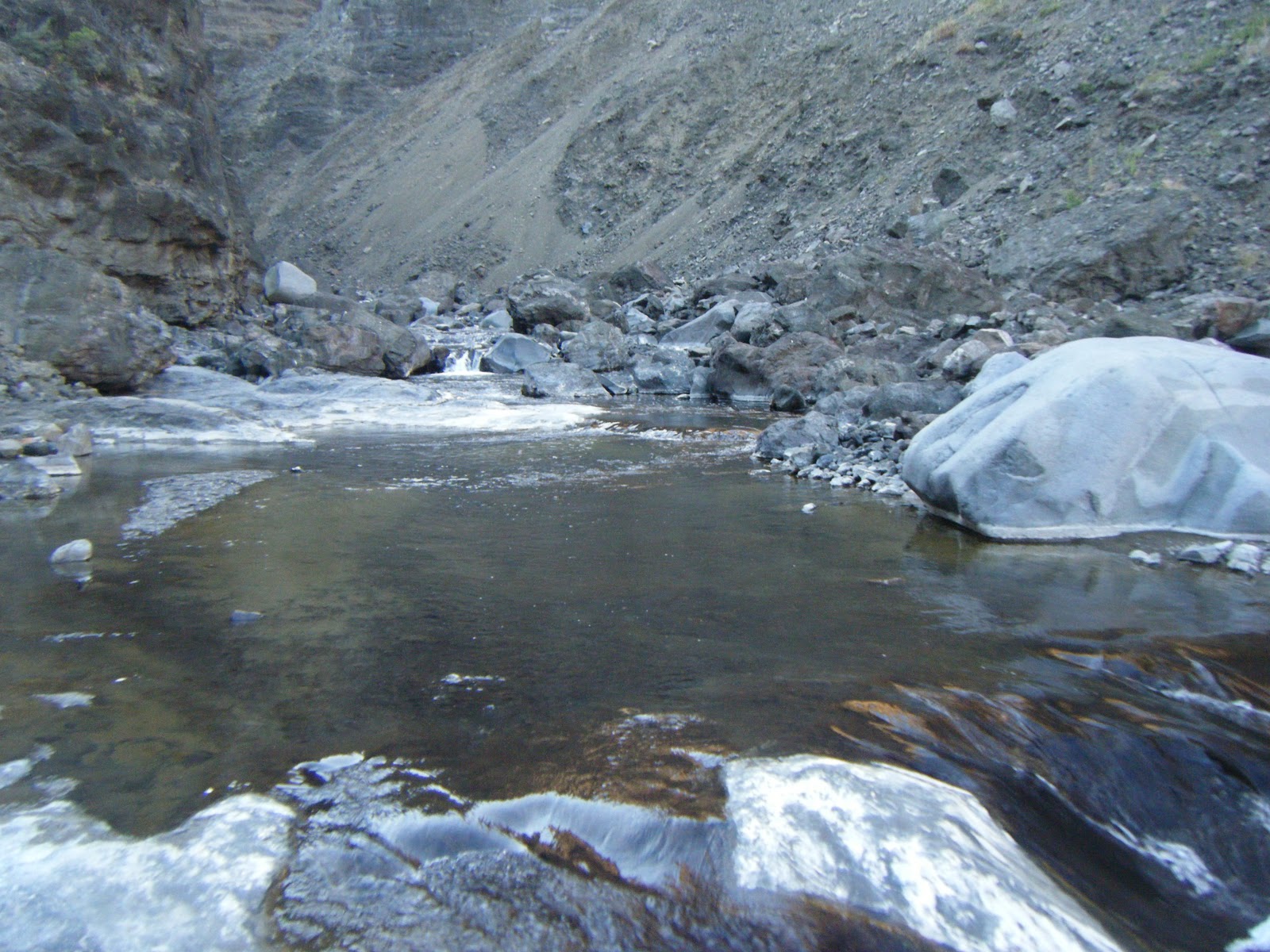
the 4th element. Eventually i took water out of a stagnant pool where
"padda vissies" were swimming between the cattle dung, but i just
decided i will rather drink dirty water and get sick than dehydrate.
The locals at CP3 tried to radio farmer rob, and showed me a road to
follow. I followed the road until it stopped. I tried to find it
again, but eventually realized i seriously must make a plan to get off
the mountain before nightfall, looking on the map i saw a river and
what looked like a farmhouse. I moved to the western side of the ridge
and words can't express how happy i was when i saw the farmhouse far
below in the valley. I felt like Bear Grills from ultimate survival,
that found civilization after an expedition. And i started making
plans on where it would be best to get off the mountain. It was 16:00
now and i had 2 hours of effective daylight left to get off the
mountain. Here again you don't realize how hight you are up until you
have to get down. This is a high mountain.
I eventually decided to get down to the river and follow it down the
mountain, as if i don't make it down in daylight i could just follow
the river and it would lead me to the farm, it would also provide me
with drinking water. It turned out to be the worst bundu bashing
experience ever and i for one like bundu bashing. It was hard, but
around 18:00 (14hours later) i reached the first farm house. It was
empty. Moving further down i saw people and went closer. I walked
strait into about 20 people having a party drinking and having a
braai, (*i froze in my steps*), (*they froze*). The one child asked
"mommy, who is this guy?" (*all quiet*). I said "I am looking for
farmer rob, am i at the right farm?", they said "No, do you know what
you are doing here?". Eventually after i told them the whole story and
being questioned and mentioning Adrian Saffy, Henk said he knows him
as he studied with him and would gladly help me get out of my
predicament. Henk phoned and let stephan also a friend know where I,
No. 6 was.
Waiting 2 hours to be fetched, I ended up having 3 tequilas and a
lekker chili dog while listening to their braai stories about iPod
player speakers that is waterproof with lights illuminating and that
can be used as vis-aas. Eventually i was fetched and stephan also had
to take strafdop.
When last were you lost on your own and without water far from civilization?
As humans I believe we are meant to run and trek over mountains, that
is what our bodies was designed to do by God in order to survive, but
modern day city life has taken us away from nature and how we were
meant to live. This weekend at the Garmin Wartail Tri challenge i
returned to nature again and had to get out of my city life comfort
zone and fight the elements to survive. What a Great feeling of
Freedom !!!! You are sure to encounter the 4 elements on this
mountain: WIND,FIRE,EARTH,WATER


